Location Maps & Information
Searching for a Location
Enter your Address, Property ID, or Kansas Uniform Parcel Number in the
My Location box at the upper left to view information for a specific location.
The "My Location" text box will validate your address, property id, or Kansas uniform
parcel number (KUPN) as you type. Once you have entered at least three valid characters, a
dropdown list will populate with possible matches. This process is also helpful in
confirming if an address or property id is valid. Clicking on the section headings that have up
and down icons will expand and collapse the information for those sections.
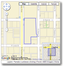 Using the Maps
The map presented in the upper right of the information page allows you to see a county
base map with property lines drawn over the top. The selected property is outlined in blue.
There are options for additional views of zoning, landuse, FEMA Flood Zones, and the most
recent AIMS imagery, found at the bottom of the map. Click each link to toggle that data
layer on or off. As you zoom in, more information becomes available. See the "FEMA 2009
Panel" link, within the data on the left, for the information on the flood zone descriptions.
Information for other parcels can be displayed by clicking on a parcel on the map.
Click the parcel on the map to load the information for that parcel. See
Google Maps
for more information about navigating the map.
A sample image of the plat map is provided for platted properties. This image can provide valuable information regarding easements, setbacks, and
other pertinent information about proposed development on the parcel.
This image is taken from the recorded plat that was recorded at
the county at the time of platting.
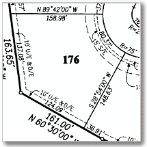
Use your mousewheel to zoom in on the image and left-mouseclick and drag the image to pan once zoomed in.
Links to download or purchase the full recorded high resolution plat is also provided.
Front Elevation Photos
Front elevation photos are updated by the County Appraiser every several years. These photos were released to the
public on September 7, 2010. When viewing pictures of the location, you can click on the thumbnails below the larger image to
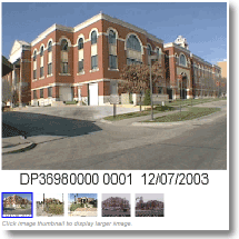
toggle those smaller images to the main image view. Mouse over the individual images to see image date
Viewing More Information
You can use your myAIMS account to Login using the link at the upper right of the page. Logging
in allows you to see additional owner information that is protected under various statutes and policies.
For more information about getting a myAIMS account, visit
AIMS.
About the data
The information in this page is made possible by the collaborative efforts of Johnson County
departments and other non-county sources. Automated Information Mapping System (AIMS)
is responsible for compiling and presenting the data on this page. Data overlaid on the Google and
Bing basemaps is intended to be a representation of the data, may contain inaccuracies, and
is provided for planning purposes only. Most of the data on this page is available for purchase
or download. Please contact
AIMS or visit the
AIMS website for more information.